Forefathers Burial Ground
Also known as Forefathers Burying Ground , Old Burying Ground
Chelmsford, Middlesex County, Massachusetts, USA
About
-
Get directions Intersection of Westford St. and Littleton Rd.
Chelmsford, Massachusetts 01824 United StatesCoordinates: 42.59745, -71.35397 - cemeteries.townofchelmsford.us
- (978)250-5245
- Cemetery ID:
Members have Contributed
Advertisement
Photos


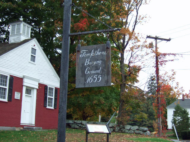
Some say the first meeting house was built in 1655, while others believe it was not built until 1659/60. The early meeting house was a general gathering place, used as not only a place of worship, but for public meetings and other social events.
The first grave was on the land of Thomas Henchman, later owned by Mrs. E.H. Warren. The Forefathers Burying Ground is thought to be the first public burial ground in town although it may have been a number of years before it was established. The earliest surviving carved stone is that of Grace Livermoar, dated 1690. The first minister, Rev. John Fiske, was buried here but it is not known where. Edward Spalding who died in 1669 was buried beside his grandson Joseph, but no stone is present to note the location of his grave.
A few uninscribed stones of rough surface appear to mark the earliest graves, but the year 1690 is the date of the first stone bearing a date. In 1702, a "rough fence", and in 1708, a "board fence" was placed around the burying ground. This was replaced in 1717 by a stone wall and in 1790 one of more permanent character was built.
In May 25, 1778, the Town appointed a committee to consider making some addition to the burying ground. In 1813, and the three succeeding years, the tombs were built at the top of the rising ground. In 1817, a piece of land owned by Moses Hale, on the Southerly side of the burying ground was added to it. In 1830, the burying ground was "repaired", and in 1838, an addition was made on the west side, a parcel being purchased of David Dickinson for $100. In 1839, the stone steps were built on the slope near the center of the old part of the burying ground. The upper flight of steps was built about 1853, when the upper row of tombs were built. In 1871, a receiving tomb was built. A triangular strip of land next to Littleton Road was annexed at this time.
The cemetery sits on 4.8 acres. The earliest headstone death date in 1690. There are 1500+ headstones.
There are approximately 102 veterans interred at Forefathers Burying Ground including 46 Revolutionary War Veterans and 45 Civil War Veterans.
The Massachusetts Historical Commission refers to this cemetery in MACRIS as CLM.804 Forefathers' Cemetery.
This cemetery is referred to as GR1 Forefather's Cemetery, Chelmsford Centre in the "Vital Records of Chelmsford Massachusetts to the end of the year 1849."
Nearby cemeteries

Chelmsford, Middlesex County, Massachusetts, USA
- Total memorials6k+
- Percent photographed98%
- Percent with GPS16%

Chelmsford, Middlesex County, Massachusetts, USA
- Total memorials693
- Percent photographed91%
- Percent with GPS7%

Chelmsford, Middlesex County, Massachusetts, USA
- Total memorials9k+
- Percent photographed57%
- Percent with GPS13%

South Chelmsford, Middlesex County, Massachusetts, USA
- Total memorials1k+
- Percent photographed99%
- Percent with GPS19%
- Added: 17 May 2000
- Find a Grave Cemetery ID: 155180

Cemetery Photos
This is a carousel with slides. Use Next and Previous buttons to navigate, or jump to a slide with the slide dots. Use Escape keyboard button or the Close button to close the carousel.


Success
Uploading...
Waiting...
Failed
This photo was not uploaded because this cemetery already has 20 photos
This photo was not uploaded because you have already uploaded 5 photos to this cemetery
This photo was not uploaded because you have already uploaded 5 photos to this cemetery
Invalid File Type
Birth and death years unknown.
1 photo picked...
2 photos picked...
Uploading 1 Photo
Uploading 2 Photos
1 Photo Uploaded
2 Photos Uploaded
Size exceeded
Too many photos have been uploaded
"Unsupported file type"
• ##count## of 0 memorials with GPS displayed. Double click on map to view more.No cemeteries found